Overview
Autonomous navigation in indoor fire-affected environments presents severe challenges due to extreme temperatures, dense smoke, and non-linear thermal dynamics. Traditional optical sensors like LiDAR or visual cameras often fail or become unreliable in low-visibility, smoke-filled scenarios. Lightweight micro-drones—such as the Crazyflie 2.1—offer a safe, non-intrusive alternative for indoor exploration, provided they can interpret local environmental cues for decision-making.
This project presents a closed-loop reinforcement-learning-based navigation framework integrated within the Webots simulation platform and ROS middleware. The micro-UAV autonomously locates high-temperature regions using only point-wise local temperature feedback, operating without prior map knowledge of the thermal field. Beyond fire localization, this framework extends naturally to tracking other spatial-temporal continuous fields, such as chemical leakages or hazardous gas sources.
Architecture & System Pipeline
The system runs in a continuous feedback loop linking physical fire dynamics with real-time drone control:
- Fire Simulation Node: Computes the temperature $T(x,y)$ at the drone’s current GPS coordinates and publishes it over ROS topics.
- Reinforcement Learning Node: Receives local temperature readings, evaluates directional gradients, and selects target waypoints based on the active exploration policy.
- Control & Execution: A proportional position controller converts target position coordinates into velocity commands, moving the drone inside Webots until position error falls below threshold.
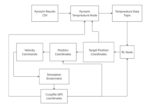
System flow: ROS-Webots closed-loop integration with Pyrosim and RL decision nodes.
Thermal Environment Modeling
To evaluate algorithm robustness across diverse thermal conditions, a dual-generation pipeline was constructed:
1. Physics-Based Fire Dynamics (PyroSim / FDS)
Realistic indoor fire scenarios were modeled using PyroSim with the Fire Dynamics Simulator (FDS) backend. Mesh-resolved node data is exported as spatial CSV files and parsed by a custom ROS node to stream real-time temperature feedback during drone exploration.
2. Analytical Thermal Fields (Superposition Models)
To complement Pyrosim with high-speed, dynamic test cases, analytical thermal fields were built using attenuation-based exponential propagation equations inspired by indoor fire fluid dynamics:
\[\frac{\Delta T_{x}}{\Delta T_{\text{ref}}} = f_{1}(N) e^{f_{2}(N) K_{1} x}\]Using the principle of superposition, secondary fire sources and thermal cold sinks were modeled to generate challenging, non-symmetric thermal landscapes.
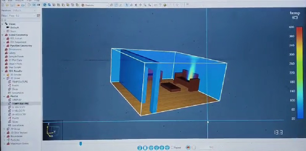
Simulated indoor fire environment and temperature distribution.
Decision-Making & Navigation Algorithms
Three spatial decision-making strategies were implemented and evaluated:
1. Greedy Hill Climbing
The drone evaluates local temperature gradients by scanning candidate points on a perimeter circle of radius $r$ around its current coordinates. It strictly moves step-by-step along the vector of maximum thermal ascent.
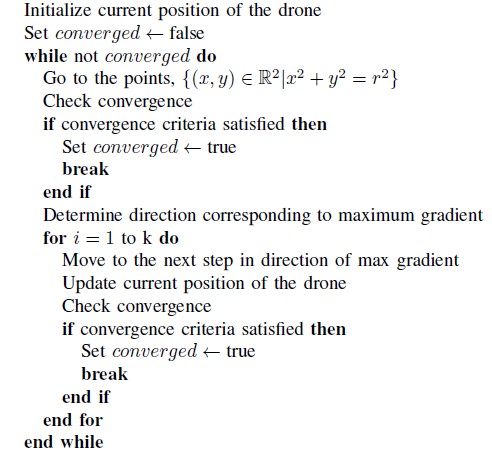
Algorithm 1: Hill Climbing Algorithm (Greedy Approach).
2. Multi-Armed Bandit (epsilon-Greedy Approach)
To avoid getting trapped in zero-gradient or local maxima regions, the agent selects a random direction with probability $\epsilon$ and exploits the highest empirical temperature gradient direction with probability $1 - \epsilon$.
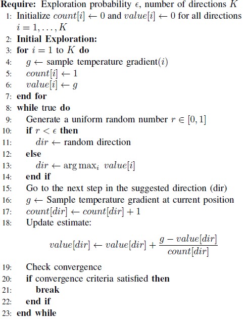
Algorithm 2: Multi-Armed Bandit Algorithm (epsilon-Greedy Approach).
3. Multi-Armed Bandit (Upper Confidence Bound - UCB)
Unlike epsilon-greedy, UCB balances exploration and exploitation deterministically by computing an upper confidence bound for each directional arm:
\[\text{UCB}_i = Q(i) + c \sqrt{\frac{2 \ln T_s}{N_i}}\]Here $Q(i)$ is the mean temperature gradient along arm $i$, $c$ is the exploration constant, $T_s$ is total steps, and $N_i$ is arm visit count. An adaptive update rule dynamically scales $c$ based on the variance of arm visits to avoid premature convergence.
Convergence & Adaptive Update Mechanics
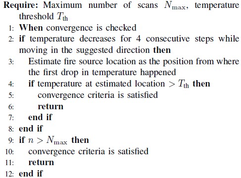
Algorithm 3 & 4: Convergence Criteria and Adaptive Update Rule of Exploration Constant.
Drone Navigation & Visualizations
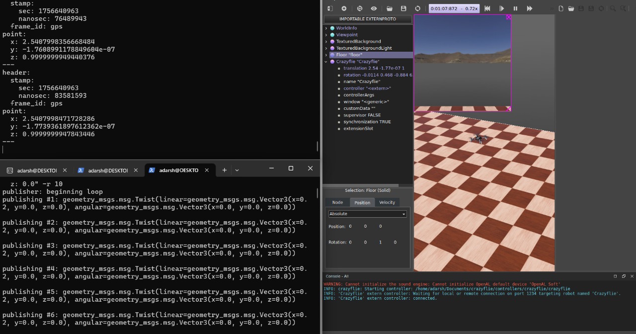
The navigation algorithms were integrated into a ROS2-based control architecture and evaluated in Webots simulation.
Fire propagation and thermal environment generated for the navigation study.
The drone was then simulated while autonomously navigating through the generated thermal environment toward the fire source.
Autonomous drone navigation using temperature-based decision making.
Simulation & Benchmark Results
The algorithms were benchmarked in a simulated 25m × 25m indoor warehouse environment (ambient baseline $20^\circ\text{C}$):
| Scenario | Algorithm | Distance Traveled (m) | Mean Squared Error | Final Position Error (m) | Convergence Status |
|---|---|---|---|---|---|
| Single Source (Near) | Greedy Hill Climbing | 39.84 | 0.0065 | 0.153 | Converged |
| epsilon-Greedy Bandit | 68.29 | 0.0227 | 0.707 | Converged | |
| UCB Bandit | 23.02 | 0.0170 | 2.915 | Partial/Exploratory | |
| Far Source (Flat Gradient) | Greedy Hill Climbing | — | — | — | Failed (No Conv.) |
| epsilon-Greedy Bandit | 55.05 | 0.0318 | 0.860 | Converged | |
| UCB Bandit | 27.87 | 0.0867 | 1.803 | Converged | |
| Thermal Sinks Distortions | Greedy Hill Climbing | 61.52 | 0.1783 | 0.262 | Converged |
| epsilon-Greedy Bandit | 79.97 | 0.2741 | 0.823 | Converged | |
| UCB Bandit | 87.64 | 0.2331 | 1.231 | Converged |
Key Takeaways
- Developed indoor fire environments using PyroSim / FDS.
- Built a ROS/ROS2 & Webots closed-loop navigation stack.
- Implemented Greedy Hill Climbing, epsilon-Greedy, and Adaptive UCB bandit algorithms.
- Unimodal / Strong Gradients: Greedy hill climbing achieves optimal efficiency and minimal distance when steep local gradients exist.
- Flat Gradients & Local Traps: Multi-armed bandit strategies (especially epsilon-greedy) prevent total navigation failure in flat thermal fields or regions containing secondary hot spots.
- Validated that lightweight micro-quadrotors (Crazyflie 2.1) can localize thermal targets using only point temperature measurements without vision/LiDAR payloads.